Looking deeper into the subsurface beneath Anak Krakatau's waters to understand how volcanoes cause tsunamis
REconstructing VOLcanic erUptions and Tsunamis Of Krakatau VolcaNo
In August 2023 the PRE-COLLAPSE team and other international scientists visited Indonesian waters with research vessel R/V SONNE to decode the mechanisms behind the devastating volcanic events at Anak Krakatau in 1883 and 2018.
During the research cruise with research vessel R/V SONNE in August 2023 the PRE-COLLAPSE team, along with other researchers from GEOMAR, the University of Birmingham, Hamburg University and four Indonesian scientists from the National Research and Innovation Agency (BRIN) surveyed the deposits of the Anak Krakatau 2018 sector collapse and the 1883 pyroclastic flow deposits using bathymetry, sediment echosounder, and 2D seismic profiles, as well as sediment gravity coring. With the new data the research team will reconstruct the geomorphological evolution of the island, identify the catastrophic events and refine the volume of the massive eruption in 1883. By unravelling the geologic processes involved, they hope to better understand the main causes of the disastrous tsunami. This information will help to better assess volcanic tsunami hazards not only at Krakatau but also at other volcanoes worldwide.
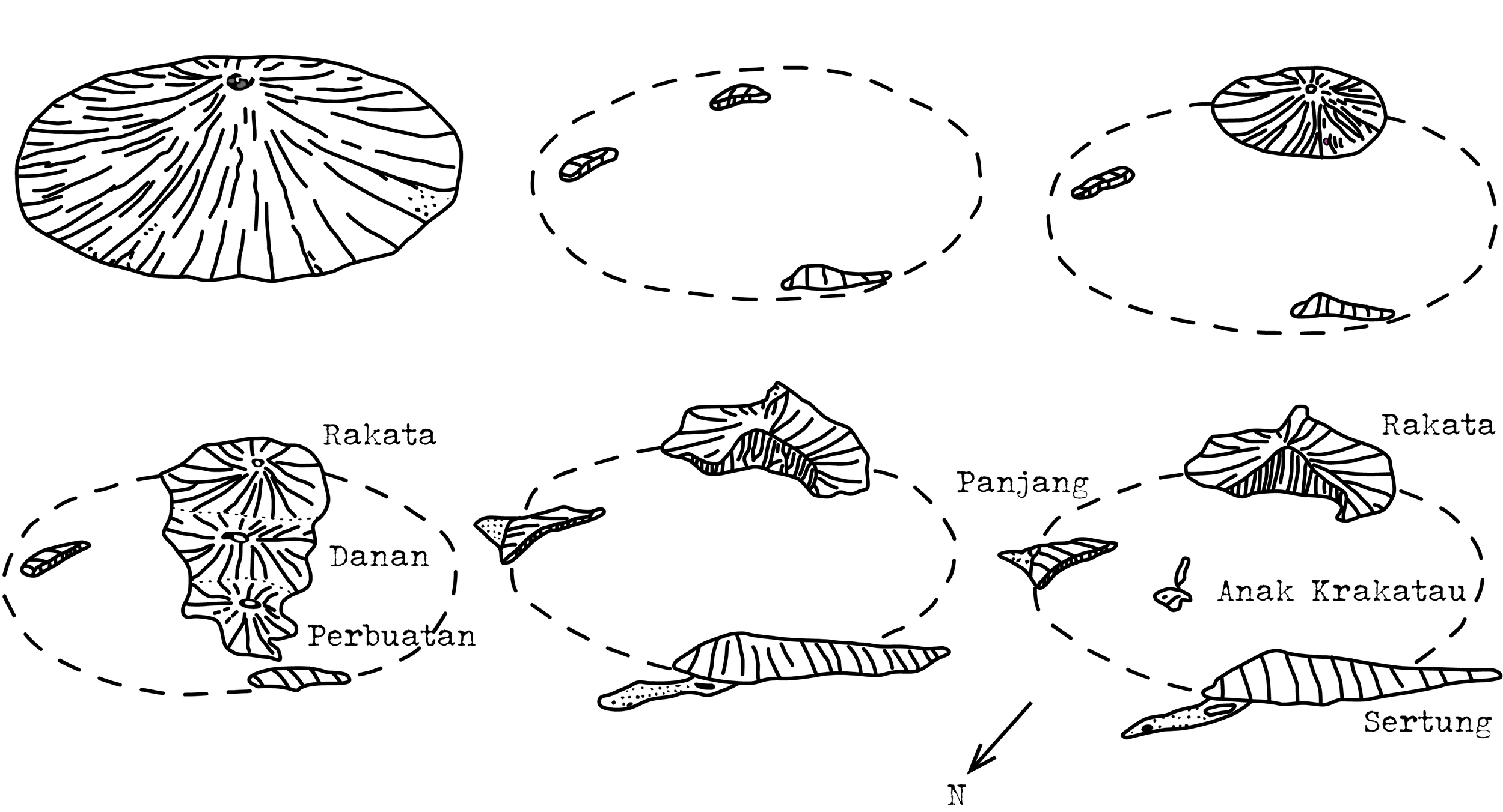
Over the course of geological history, Krakatau, a volcano nestled between the Indonesian islands of Java and Sumatra, has undergone several collapses and rebirths, changing the geography of the area constantly over time. Prior to the events of 1883, a massive caldera-forming eruption potentially around 416 AD occurred and a very productive subsequent eruptive cycle gave rise to three aligned, active volcanic vents.
In 1883, Krakatau underwent another substantial eruption that wiped out a large part of the three volcanoes and produced a 250 m deep caldera. Devastating tsunamis flooded the adjacent coasts of Sumatra and Java. Pyroclastic flows crossed the Sunda Strait and reached the coast of Sumatra. Over 36,000 people lost their lives in this deadliest volcanic event in historical records. After a quiescent period of less than half a century, Anak Krakatau - child of Krakatau - reached the sea surface in December 1927. Since then, Anak Krakatau has erupted repeatedly.
In December 2018, Anak Krakatau collapsed, triggering a tsunami that resulted in 430 deaths and caused widespread destruction along the coastlines.
R/V SONNE Expedition 299/2
REconstructing Volcanic Eruptions and Tsunamis Of Krakatau Volcano - REET
Chief Scientist: Professor Dr Morelia Urlaub (GEOMAR)
Start: 15th August 2023, Singapore
End: 2nd September 2023, Port Louis (Mauritius)
We need to look deeper- seismic surveys to find out what caused the tsunamis during the 1883 eruption and 2018 sector collapse
Although volcanic events currently stand as the second-most common source for tsunamis and have caused more than 55,000 casualties in the last 250 years, conventional tsunami early warning systems are not designed to warn for volcano induced tsunamis. The tragedy in 2018 exposed a significant gap in our ability to forecast such events, shedding light on the urgent need for a deeper understanding of volcanic tsunamis.
“The current tsunami simulations and predictive models at Krakatau are not sufficient to capture the geological mechanisms behind it”, explains Professor Dr Morelia Urlaub from Helmholtz Centre for Ocean Research Kiel, lead scientist of this part of the expedition. “But these mechanisms are critical for improving accuracy to the prediction of various scenarios!”. The models are constrained by the availability and accuracy of input parameters. These are, for example, the volumes of the mass movements, or explosion depths and intensities of the past events.
During the 1883 eruption, observations were documented by local residents, and the relative sea level from this period is known. On land, the volcanic deposits from pyroclastic flows have been studied in detail. What is unknown is what types of mass wasting deposits and how much of it can be found on the seafloor. The marine reflection seismic profiles acquired during the research cruise with R/V SONNE fill gaps as they cover the volcanic material deposited in the ocean offshore.
Pyroclastic flows entering the ocean and the movement of huge rock masses due to the caldera collapse caused large water masses to be displaced, resulting in the formation of a huge tsunami wave. But was it only one event or were there different phases of mass movement that accumulated in the tsunami wave? The genesis of volcanogenic tsunamis is often complex and may involve underwater explosions, earthquakes, caldera collapse, pyroclastic flows, slope instabilities, shock waves or a combination of these processes. The PRE-COLLAPSE team aims to determine the relative timing and magnitude of the different processes that might have influenced the cascading triggering mechanisms behind the 1883 Krakatau tsunami. This understanding is crucial to answer key questions such as: What was the primary cause of the most deadly volcanogenic tsunami in history? How big was the 1883 eruption really?
During the SONNE cruise the researchers were now able to make the marine 2D seismic measurements needed to identify the source processes and volumes of the disastrous 1883 eruption and collapse event. They use the seismic surveys to unravel the tsunami source mechanisms by taking a detailed look at the sediment structures to investigate how volcanic sedimentary material was eroded and redeposited after the collapse. By interpreting the high-resolution seismic profiles the researchers hope to be able to tear apart what exactly happened in 1883. Hints give for example so called undulating seafloor bedforms, wavy structures in the ocean sediment.
Sediment gravity cores collected during the cruise contain layers of volcanic material that have accumulated on the seafloor, potentially spanning several hundred years. They will be used to extend the geological record of eruptions and catastrophic events at Krakatau volcano both in terms of time and space.
Within only 60 hours, the researchers and technical staff aboard the R/V SONNE acquired 380 km of 2D seismic data and collected 34 m of sediment with the gravity corer. Ensuring ship time, especially aboard esteemed research vessels such as the R/V SONNE, and obtaining the necessary research permit is challenging. After all, the exhaustion from the work fades behind the satisfaction of successfully collecting a significant amount of data and sediment material within a short window of less than three days. The integration of these different tools, combined with existing data and data from other volcanoes, for example at Santorini is key to unravelling the complexities of volcanic cascading hazards, including volcanic tsunamis.
The time together on the ship and the collaborative work including four Indonesian scientists offered the opportunity to make plans for future collaboration. “The synergy between international and Indonesian researchers brings a wealth of perspectives to the research and we are looking forward to further collaborating on the data that we collected”, says Morelia Urlaub.
Bathymetric map with lines showing the 2D Seismic survey aquired from R/V Sonne around the Islands of Krakatau in August 2023


